
Iran's 5,000 Mines Threaten Strait of Hormuz Oil Traffic


- Details
- Category: Marina Mercante
- Published on Wednesday, 11 March 2026 09:34
- Written by Administrator2
- Hits: 80
CHOSUM
Naval mines, missile strikes, and GPS jamming could disrupt global oil shipments, risking price surges and navigational chaos
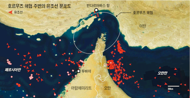
The Iranian Revolutionary Guard Corps warned on the 2nd that “not a single drop of oil will pass through the Strait of Hormuz,” drawing global attention to whether an actual blockade will occur. If this route, which handles approximately 20% of the world’s maritime crude oil shipments, is blocked, a surge in international oil prices is inevitable. Experts argue that even without a full physical blockade, Iran could achieve practical effects through several threatening military actions. Merely raising concerns about the sinking of super-tankers worth over 100 million USD could prompt shipping companies to voluntarily avoid the strait.
The narrowest part of the Strait of Hormuz is only 33 kilometers wide, forcing large vessels to pass through Iranian territorial waters. If Iran intends to enforce a blockade, the most feasible method would be naval mines. The U.S. Defense Intelligence Agency (DIA) estimates Iran possessed over 5,000 mines as of 2019. Iran also operates numerous vessels capable of rapidly laying mines and has historical precedent: during the 1980s war with Iraq, it damaged U.S. Navy ships by deploying mines in the same region.
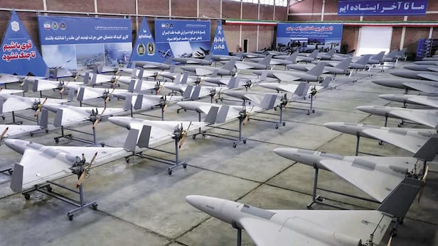
Direct attacks on vessels using missiles and drones are another option. Similar to how Yemen’s Houthi armed group attacked tankers with missiles since 2023, paralyzing Suez Canal traffic, Iran could conduct small-scale strikes. The Iranian Revolutionary Guard has recently seized tankers linked to Britain, Greece, South Korea, and Israel near the Strait of Hormuz and the Gulf of Oman using helicopters and small high-speed boats.
A new method has also emerged. Following Iran’s electronic warfare drills last month, over 1,100 vessels passing through the Hormuz area experienced GPS jamming and malfunctions in their Automatic Identification Systems (AIS). Ship coordinates appeared dozens of kilometers inland or over nuclear power plants, causing navigational chaos. Without firing a single shot, this approach increases collision risks and raises insurance costs, pressuring shipping companies to steer clear.